New Zealand. Glacial Landscapes of Milford Sound
Milford Sound (aka Piopiotahi) is a fjord in the southwest part of New Zealand’s South Island. It is located within the 1.2-million-hectare Fiordland National Park and the Wahipounamu World Heritage Site. “Piopiotahi” comes from the Māori name for a now extinct, thrush-like bird called a piopio. Described by author Rudyard Kipling as the “Eight Wonder of the World,” the Sound is one of New Zealand’s most popular tourist destinations with more than 600,000 visitors each year. Stretching 15 kilometers from the Tasman Sea to Dale Point, it was formed by the movement of massive valley glaciers that carried away rock, forming U-shaped valley profiles. Beyond steep cliff faces on either side of the Sound are peaks such as Elephant (1,517m) and Lion (1,302m). With 6,400mm of annual rainfall, Milford Sound is one of the wettest places in New Zealand and among the most remote. While most people arrive by car or boat, a few make the journey on foot, following a trail called the Milford Track though McKinnon Pass that originates near Lake Te Anau.

The Māori lived in the area around Milford Sound for more than five hundred years before the arrival of Europeans. According to a Māori legend, the Sound was created by Ŧu-te-raki-whanoa, an atua or god-like being, who was tasked with creating the coastline. The atua’s powerful prayers carved the waterway through towering rock. In 1823 a seal hunter named John Gano became the first European to visit the Sound, and soon after he named it after his birthplace in Wales. In the late 1800s a Scotsman named Donald Sutherland became the first permanent resident. Selecting a site near Bowen Falls, Sutherland and his wife opened a hotel there in the early 1900s. Milford Sound is the only glacial fjord within Fiordland National Park that is accessible by road. The 171-kilometer drive between Queensland to Te Anau took two hours in our rental car. The curving route went south and west before turning north. Along the way we passed open areas filled with sheep, some walking in long lines between fields. Sheep were introduced to New Zealand in 1774 by explorer James Cook. Today about 13 million live on New Zealand’s South Island, ten for every human.

We stopped for the night in the town of Te Anau which means “place of swirling waters.” Located on the eastern shore of glacially formed Lake Te Anau, the town has about 3,200 residents. The lake is 65 kilometers long and sits at an elevation of 210 meters above sea level. It is the second largest lake in New Zealand and among the deepest, reaching 425 meters below sea level. Most of the 344 square kilometer lake is inside Fiordland National Park. A bicycle and walking pathway along the lakeshore took us to a dam/spillway where electrical power is generated. Leaving Te Anau the next morning we drove the remaining 118 kilometers to Milford Sound, passing through the Darran Mountains and a tunnel excavated through Homer Saddle. Work to build a 1.2-kilometer tunnel was completed in 1953. It is one-way, so lines of cars take turns with guidance from stoplights.
On arriving at Deepwater Basin near Milford Sound, we climbed aboard a water taxi for a ten-minute trip to the Milford Track Trailhead at Sandfly Point. Milford Track was described by poet Blanche Banghan in 1908 as the “finest walk in the world.” Passing a hut used by hikers waiting for the water taxi, we followed the trail along the bottom of a cliff face and through temperate rainforest featuring massive ferns and prehistoric looking trees such as lancewood and mossy beech. The Māori People once used the route to transport valuable greenstone used in trading. Along the trail we noticed wooden boxes with wire mesh at each end, some with eggs inside. We learned that they are traps for catching animals that prey on flightless birds called weka. With brown plumage, weka are about the size of a chicken. The traps have been set to catch feral cats, possums, rats, and stoats, a weasel-like mammal introduced to control New Zealand’s rabbit population.

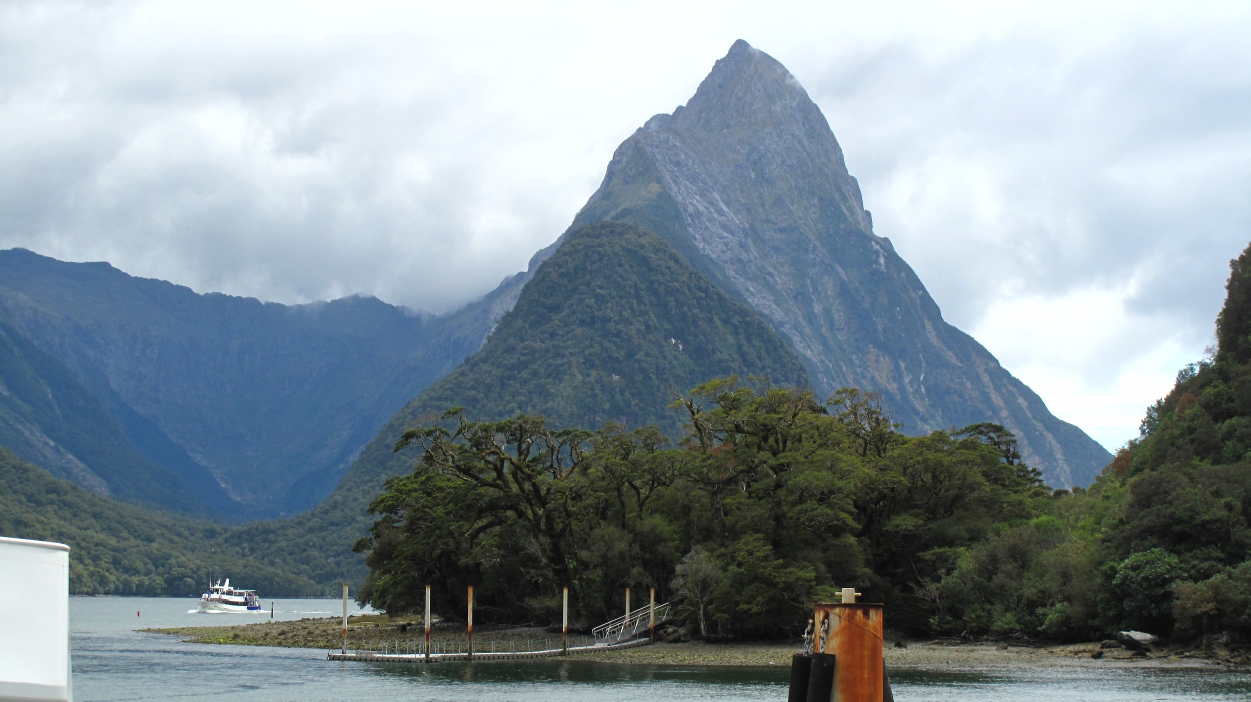
From the passenger terminal it’s possible to see the iconic Mitre Peak, among the most photographed places in New Zealand. Rising upwards from the Sound, the 1692-meter-high glacial horn forms a triangle with a sharply pointed peak. Its symmetrical shape was formed by valley glaciers removing nearly equal amounts of rock from two sides. Our tour boat continued northwest past a series of waterfalls called the Four Sisters. At Seal Rock we slowed down to see a few harbor seals sunning themselves. We continued past Fox and St. Anne Points and into the Tasman Sea. James Cook sailed passed the entrance to the Sound in 1769 during an expedition to map New Zealand. Cook and other explorers were likely concerned that their ships might become trapped within the narrow inlet surrounded by high rock walls. On our return to Milford Sound’s small terminal we passed two permanent waterfalls, Stirling which drops 151 meters, and Lady Bowen that drops 162 meters. Our boat pulled in close to Stirling so riders on the bow could experience the spray in what the crew described as a “waterfall facial.” We learned later that Bowen Falls is used as a water supply and to generate electricity for buildings in and around the Sound.

Before departing the South Island, we stopped for a few hours in Queensland (population 27,000), a city located on the northwestern edge of Z-shaped Lake Wakatipu. Built on a place first settled by the Māori, Queensland was named for Ireland’s city of the same name. Europeans began arriving in 1860 shortly after gold was discovered in the area. After parking we purchased tickets to see the Kiwi Park and Wildlife Sanctuary. We were excited about the possibility of seeing kiwi, flightless birds that are the size of a small chicken. They have short, stout legs and nostrils at the end of long, thin beaks. We entered a building that was kept dark to provide a comfortable environment for several kiwi to move around behind glass enclosures. We also purchased tickets to ride the Skyline Gondola. Opening in 1967, the gondola transports visitors to the summit of Bob’s Peak (1,099m). A mountain bike trail and 1,600-meter luge track are visible from the gondola. From the restaurant at the top, we could see Mt. Deware (1,310m) to the north, Cecil Peak (1,978m) to the southwest, and Single Cone (2,319m) to the southeast.
