Korea. Between the Koreas: Touring the Joint Security Area and Third Tunnel of Aggression
The Korean War began in June 1950 when communist forces from the north invaded the southern part of the Korean Peninsula. After years of vicious fighting and more than three million casualties, the front stabilized at the 38th Parallel, close to where the war began. In July 1953, an armistice was signed creating the Korean Demilitarized Zone (DMZ), a four-kilometer wide buffer extending 250 kilometers from the Yellow Sea to the Sea of Japan and roughly following the 38th Parallel. To facilitate meetings and negotiations between North Korea and the United Nations Command (represented by South Korea and the U.S.), the Joint Security Area (JSA) was created inside the DMZ and about 800 meters south of the village of Panmunjom. Although technically still at war, both North and South Korea allow tourists to visit the JSA.
I booked my tour through a South Korean travel agency. Other than having a valid passport, there are no special requirements to see the JSA. My visit began at the City Hall Subway Station in Seoul where I boarded a bus for the 44-kilometer ride to the JSA. Following a lunch stop, we crossed into the DMZ for a briefing at Camp Bonifas where each visitor was required to sign a document acknowledging the risks of travel into the DMZ. The briefing included instructions not to make gestures that might provoke or offend North Korean guards. Indeed, the JSA has witnessed border incidents including the brutal 1976 deaths of two U.S. servicemen and the defection of a Soviet tourist who ran to the South Korean side and was subsequently chased by North Korean guards. In July 2023, a U.S. soldier participating in a JSA tour sprinted into North Korea.
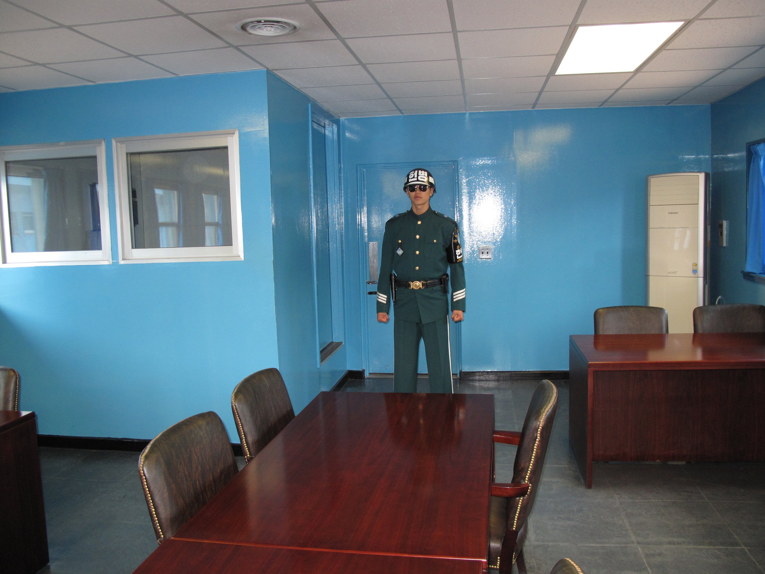
Near the center of the JSA is Conference Row, comprised by one-story blue and white buildings that straddle the demarcation line and are used for meetings between North Korean officials and representatives of South Korea and the United Nations. Entering a blue building, we were greeted by a grim-faced Republic of Korea (ROK) soldier wearing a green uniform, helmet, and dark sunglasses. To be selected to serve within the JSA, ROK soldiers must be at least 170 centimeters in height and hold a black belt in judo or taekwondo. Outside Conference Row we could see a North Korean guard standing near the steps of North Korea’s Panmungak Hall.
I also visited what South Koreans call the 3rd Tunnel of Aggression, built to transport North Korean soldiers across the border during a surprise attack. Nearby, we stopped at Freedom Bridge where 12,773 prisoners of war held by the North crossed the Imjin River into South Korea in 1953. We also toured Dorasan Station, located on the Gyeongui Rail Line. Just 650 meters south of the DMZ, the station symbolizes the eventual reunification of the two Koreas.
The first and second tunnels of aggression were discovered in 1974 and 1975. Although its existence had been made known to South Korean officials by a North Korean defector in 1975, the 3rd Tunnel wasn’t discovered until 1978. Slightly more than 1,600 meters long, two meters wide, and 73 meters below ground, the 3rd Tunnel was capable of transporting 30,000 soldiers per hour into South Korea. Photography isn’t permitted so I left my camera in a locker inside the visitor center before beginning the tour. Wearing hardhats, we descended down a side passageway created to connect the visitor center with the 3rd Tunnel (there is also a train that takes visitors to the tunnel). The 3rd Tunnel was designed with a slight incline towards the north to prevent it from being blocked by water.
The tourist path ended abruptly at a concrete barrier near the military demarcation line. Although visitors can’t cross the barrier, it’s possible to look farther down the tunnel through a small window. When South Korean leaders announced their discovery of the 3rd Tunnel, the North denied its existence, later claiming it was a coal mine shaft. This was quickly debunked when it was noted that the tunnel passes through igneous rock and not sedimentary rock layers where coal is found.


